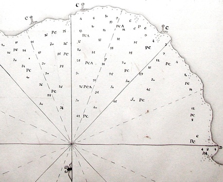
The Spanish Anchorage, Easter Island manuscript map
1770
ink on laid paper 36,3 x 41,9 cm (14 2/8 x 16 5/8 in.)
The Daulton Collection
(detail only displayed)
|
In addition to its holdings of art and material culture, The Daulton Collection includes a small but significant group of materials (maps, correspondence, photographs, books, etc.) relating to the history of exploration, travel, and science.
Highlights of the collection include, among other items:
1) one of the first two manuscript maps of Easter
Island, both created on the 1770 Spanish expedition to the island (the other
map is in the Library of Congress, Washington, DC); the Daulton Collection's map, a map of the Spanish anchorage, contains the first drawings of
moai, the monumental stone statues for which Easter Island is world-famous; 2)
one of the only privately-held collections of original material relating to
Hiram Bingham’s expeditions to Machu Picchu, consisting of the personal archive
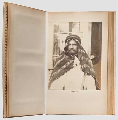
of Albert H. Bumstead, Bingham’s topographer; 3) an important archive consisting of more than 100 original photographs from
Albert von Le Coq’s German Turfan Expedition to Central Asia, 1904-05, in
search of the “buried treasures of Chinese Turkestan”; 4) a small, but
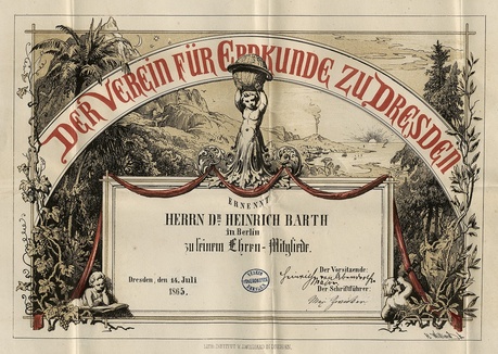
important, group of manuscript correspondence, including field reports, and other documents relating to Heinrich
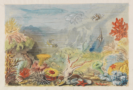
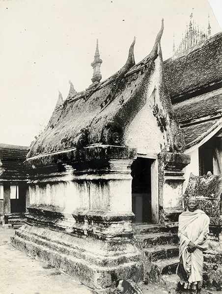
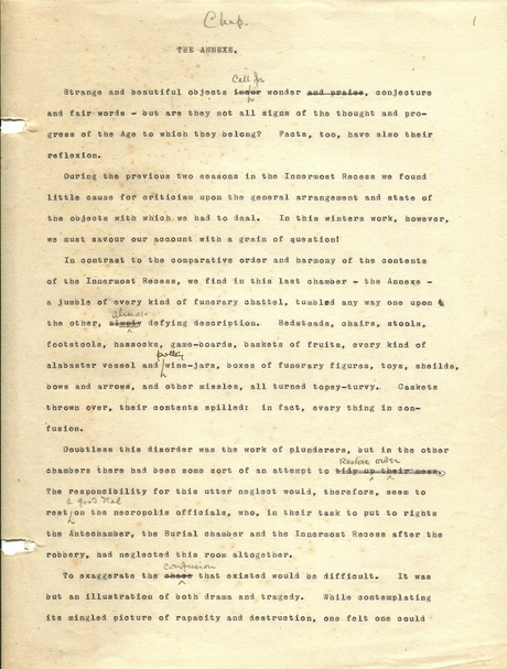
Barth and his exploration of North Africa, 1850-55, from Tripoli to Timbuktu; 5) an autograph draft manuscript of evolutionary biologist Ernst Haeckel's Indische Reisebriefe [Indian Travel Letters] (1882), as well as one of Haeckel's original watercolor illustrations for Arabische Korallen [Arabian Coral] (1876), one of the first scientifically accurate depictions of a coral reef; 6) a visual archive of French archaeologist Henri Parmentier (1871-1949), relating to the ancient art and architecture of India and Southeast Asia, consisting of 180 photographs and 56 ink and pencil drawings; 7) a large and important archive of the last remaining privately-held papers of anthropologists Katherine Routledge (1866-1935) and her husband William Scoresby Routledge (1859-1939), relating to their expeditions and work in East Africa, Easter Island, Jamaica, and French Polynesia, and consisting of diaries, working notes, photographs, and illustrations, among other materials; 8) the working manuscript of chapter three ("The Annexe") of Volume
III of archaeologist Howard Carter's work The Tomb of Tutankhamun (1933), the account of his world-famous 1922 discovery, being a ten-page typescript with numerous corrections and annotations, as well as a few sketches, in Carter's hand, in pencil
and ink, opening: "Strange and beautiful
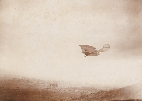
objects call for wonder, conjecture and fair words ...."; and 9) a rare and unique photograph capturing aviation pioneer Otto Lilienthal's flight in the Rhinow Hills near Berlin, 1893.
|
Albert H. Bumstead (1875-1940) View of Machu Picchu, as the site was being cleared of the jungle overgrowth during the Yale-National Geographic expedition led by Hiram Bingham III 1912 gelatin silver photograph The Daulton Collection
|
Unidentified Photographer Expedition Member wearing local headdress Albert von Le Coq Turfan Expedition 1902 gelatin silver photograph The Daulton Collection
|
Ernst Haeckel (1834-1919) Arabische Korallen (Arabian Coral) circa 1876
watercolor on thin paper 18 x 27 cm (sheet 28 x 35 cm) The Daulton Collection
|
Henri Parmentier (1871-1949) View of Monastery in Laos first half 20th century (probably circa 1910) gelatin silver photograph The Daulton Collection
|
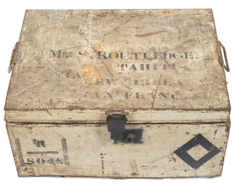
Katherine Scoresby Routledge (1866-1935) cargo trunk (one of two), containing expedition papers circa 1913-1923 painted and stenciled steel or tin W 17 3/4 x L 23 x D 10 3/4 in. The Daulton Collection
|
Howard Carter (1874-1939)The Tomb of Tutankhamun, working manuscript of chapter three ("The Annexe") of Volume III circa 1933 ten-page typescript with numerous corrections and annotations, as well as a few sketches, in Carter's hand, in pencil and ink
|
Heinrich Barth (1821-1865) Certificate of his appointment as honorary member of The Geography Society, Dresden [Der Verein für Erdkunde zu Dresden] 1865 two-toned lithograph hand-signed by the
chairman, Major Heinrich von Abendroth, Dresden 14.VII.1865 The Daulton Collection
|
Alex Krajewski (Krajewsky), court photographer of Prince Aribert von Anhalt, active in Berlin, 1890s Otto Lilienthal flying one of his gliding planes near Berlin,
Rhinower Berge, Germany
1893
vintage collodion paper print, mounted to original ornamental board
15,2 x 20,9 cm
The Daulton Collection
condition: slight surface rubbing and surface soiling; otherwise in very good condition
Published in Prometheus. Illustrierte
Wochenschrift über die Fortschritte in Gewerbe, Industrie und Wissenschaft.
4. Jg., No. 220. Berlin 1893, ill. p. 184 (no. 87).
Discussion:
"The evolution of photography and aviation shares
interesting similarities. In 1884, Ottomar Anschütz began capturing images of
storks in flight, marking the first momentary snapshots in the history of
photography. By 1890, he developed the 'Tachyscope,' displaying
sequential images of people and animals in motion, which gained popularity at
the 1893 Chicago World's Fair, highlighting advancements in transportation and
industry through widely distributed photographs. In 1891, Otto Lilienthal initiated
his flight experiments, lasting five years until his unfortunate death in 1896,
due to a flight accident. During this period, photographers such as Ottomar
Anschütz, Carl Kassner, Richard Neuhauss, and Alex Krajewski documented
Lilienthal's flights near Berlin. These images often circulated as photo
postcards and served as crucial documentation for Lilienthal. Unfortunately,
the glass negatives of Lilienthal's photographs, archived in the Deutsches
Museum in Munich, were destroyed during WWII. This particular image, part of a
series by Alex Krajewski capturing Lilienthal's flights in the Rhinow Hills
near Berlin, is exceptionally rare in its large format and good condition, with
only eight images from this series preserved in the photo archives of the Otto
Lilienthal Museum in Anklam." B. The Lilienthal Museum does not own a print of this photograph, which may be unique.
|
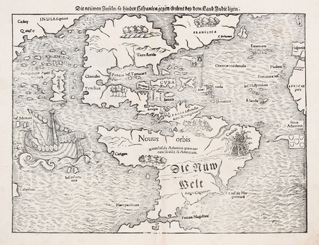
Sebastian Münster (Ingelheim near Mainz 1488-1552 Basel)
Die Nüw Welt [The New World], or Die neüwen Inseln [The New Islands]
circa 1572, German edition
woodblock engraving
image 25,5 x 34 cm (10 x 13 1/2 in.)
The Daulton Collection
References:
Philip C. Burden, The Mapping of North America (Rickmansworth: Raleigh Publications, 1996), 12
Discussion:
First published in 1528, six years after the conclusion of Ferdinand Magellan's pioneering voyage of circumnavigation, Münster's map was the first map of "The New World," i.e., the first separate map of the Americas. He incorporated the findings of Magellan, most notably the navigable passage at the bottom of South America connecting the Atlantic and Pacific oceans -- the Strait of Magellan ("Fretum Magaliani") -- and decorated the map on the left with an image of Magellan's ship, the Victoria. (Jack Daulton)
"One of the most important maps of the 16th century which brought the name 'America' into the lexicon. It is the earliest to show all of North and South America in a true continental form with a continuous coastline. South America is more accurately mapped than the North. Japan (Zipangri) is shown as being close to modern-day California, the Yucatan peninsula is shown as an island and the lake at Temistitan is connected to the Gulf of Mexico. The northeastern portion - labelled 'Francisca' - has a settlement called 'C. Britonum' indicative of British early exploration and fishing in the area. A vignette on the east coast of South America shows tree branches adorned with human limbs and the word 'Canibali', leaving the viewer in no doubt as to the dangers awaiting travellers to this region. The large ship in the Pacific Ocean is the 'Victoria', the only surviving ship of five on Magellan’s voyage. The two flags on the map are those of Spain and Portugal, emphasising the influence of these two European powers in the region." (DWA)
|
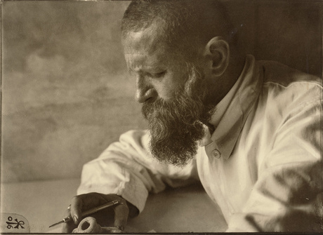
Self-Portrait of archaeologist Robert Johann Koldewey in Babylon 1906 vintage large format, sepia-toned gelatin silver photograph
38,5 x 53 cm flush-mounted to board dated in the negative in lower left corner
annotated in ink on mount verso
The Daulton Collection
Condition: edges slightly frayed; small, retouched scratch; liquid surface spot in right area; otherwise a rich tonal print in very good
condition.
References:
Walter Andrae. Babylon. Die versunkene Weltstadt
und ihr Ausgräber Robert Koldewey (Berlin: De Gruyter, 1952), ill. frontispiece.
Discussion:
A self-trained archaeological historian of the
classical period, Robert Koldewey (Blankenburg-Harz 1855-1925 Berlin) was signed on as a participant to the American
excavation expedition under Joseph Thacher Clarke of Ancient Assus in Greece in
1883, where he learned excavation methods and how to recover ancient remains.
The German Archaeological Institute then employed him for various excavations in
the Ottoman Empire. His most important work involved the excavations in Babylon
from 1898-1917 where his most significant excavation was the Processional Way
and the Ishtar Gate as well as the foundations of the Tower of Babylon. Along
with Schliemann, Humann, Conze and Dörpfeld, Koldewey is among to the most
important archaeologists of this era.
|
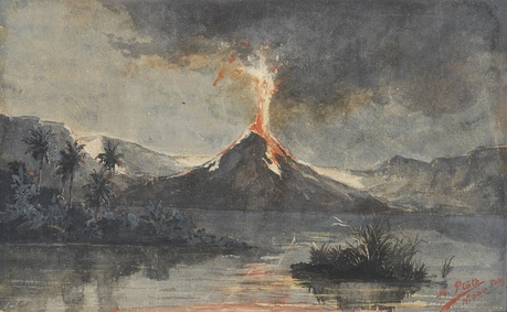
Adolph Gustav Plate (Hanover 1874-1914 Sydney)
Niuafoʻou volcano erupting
circa 1895
watercolor on paper
12.6 x 20.2 cm
signed and titled lower right: "A. Plate Nioua Foou"
The Daulton Collection
Provenance: Collection of Paul Clarke and thence by descent until purchased by The Daulton Collection in 2024.
Niuafoʻou is the northernmost island in the Kingdom of Tonga, located in the southern Pacific Ocean between Fiji and Samoa, in the "ring of fire."
Adolph Gustav Plate was an artist, travel writer, publisher, and editor who travelled the Pacific and documented the indigenous cultures and peoples of Fiji, Tonga, Samoa, and Australia through paintings and writings. In Samoa, he made the acquaintance of Robert Louis Stevenson.
Adolph was the father of modernist artist Carl Olaf Plate (1909-1977).
Adolph Gustav Plate created other artworks depicting Niuafoʻou. See: Cassi Plate, ed., A Restless Life: Journeys through the Pacific, Asia and Australasia, 1887-1913, Adolph Gustav Plate (Emu Plains, NSW, Australia: Lewers Bequest and Penrith Regional Art Gallery, 1996), ills. at pg. 10.
|
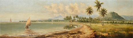
Adolph Gustav Plate (Hanover 1874-1914 Sydney)
View of Apia, Samoa
1891
oil on canvas
67 by 228 cm (26¼ by 89¾ in.),, unframed
89 by 251 cm (35 by 98¾ in.), framed
signed, dated and inscribed lower left: "A. G. Plate APIA 1891"
The Daulton Collection
Provenance:
Sir Berry Cusack-Smith, K.M.C.G., 5th Baronet (1859-1929; British Consul in Samoa from 1890 to 1898); thence by descent to Sarita Catherine Williamina Davies, West Sussex
Sotheby's, London, 7 June 1989, lot 123
Purchased at the above sale by British private collectors; thence by descent to their child
Discussion:
The white building at the centre of the painting is the British Consulate and the woman in the sailing boat on the left is believed to be Mrs. Winifred Cusack-Smith. The Cusack-Smiths moved into Vailima, the home of Robert Louis Stevenson, after he died in 1894; presumably this painting of Apia was displayed at the British Consulate and then at Vailima.
The mountain on the right side of the painting appears to be Mt. Vaea, which overlooks Vailima; the tomb of Robert Louis Stevenson is on the summit of Mt. Vaea.
Condition: Original canvas. There is a pattern of stable pigment separation to the sky. There are also scattered little raised dots, which appear to be grains of sand, inherent to the artistic process, and possibly an indication that the work was painted in situe, en plein air. Under ultraviolet light there are a few scattered strokes of retouching visible, mostly to the upper part of the composition, highlighting the edges of the peaks in the background and to some of the clouds.
|
Contact:The Daulton Collection Los Altos Hills, California e-mail: thedaultoncollection@outlook.com
|
|
|